Location analysis
Property location analysis
What buyers learn about the place on a property website by nmvt - and what the agent finds in the location check. We find, analyse and clearly present publicly available data for the exact address. The website shows only favourable and neutral information; risks are for the agent.
How the analysis is made
- 1
Address and documents
We take the address from the agent's documents, for houses and plots also the parcel numbers. We never change or recalculate the agent's figures - if they do not match the registers, we say so.
- 2
Data for the address
For the exact address we download data from public registers and maps - land register, statistics, timetables, zoning plan and more. Every figure carries the date it applies to.
- 3
Sorting
Favourable and neutral information goes on the website for buyers; risks and sensitive information go into the location check for the agent. A block without reliable data is left out.
- 4
Clearly presented
Numbers become sentences, charts and maps. Technical terms are explained in the glossary and sources are listed in the “Data sources” window in the website footer.
Blocks on the property website
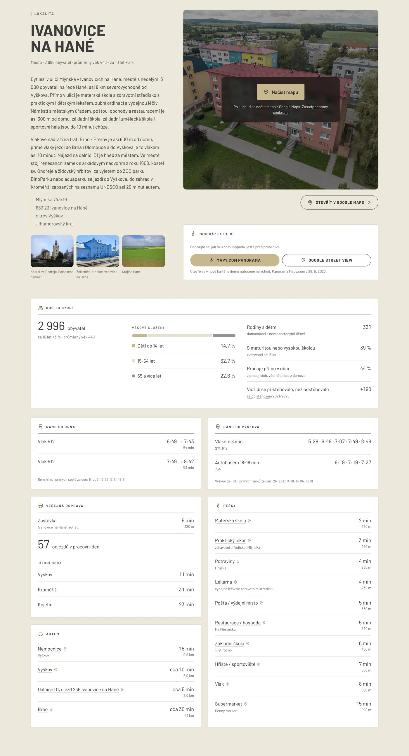
Each block appears only when there are reliable data for the address and the information is favourable or neutral. The examples come from the website of a flat in Ivanovice na Hané, utilities from the pilot website of a family house.
Walking distance and driving times
Basic and PremiumWhat is within walking distance and how far it is to town by car.
What it shows
- Shop, school, nursery, doctor, pharmacy and playground with walking time from the door
- Map of the area and the “Everything within reach” strip
- Driving times to 3-5 destinations - district and regional town, hospital, motorway
- Place names link straight to Google Maps
Sources: OpenStreetMap, Ministry of Education (school register), Institute of Health Information (healthcare providers), ČÚZK (RÚIAN), OSRM routing over OpenStreetMap
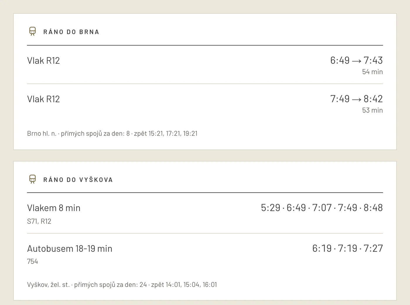
Public transport in the morning
PremiumHow to get to work and school from here without a car.
What it shows
- Nearest stop and station with walking time
- Real morning departures to town and how long the journey takes
- Connections back in the afternoon and number of connections per day
Sources: GTFS timetables of integrated transport systems and the national timetable information system (CIS JŘ)
Internet, 4G/5G signal and noise
PremiumFor working from home and quiet living.
What it shows
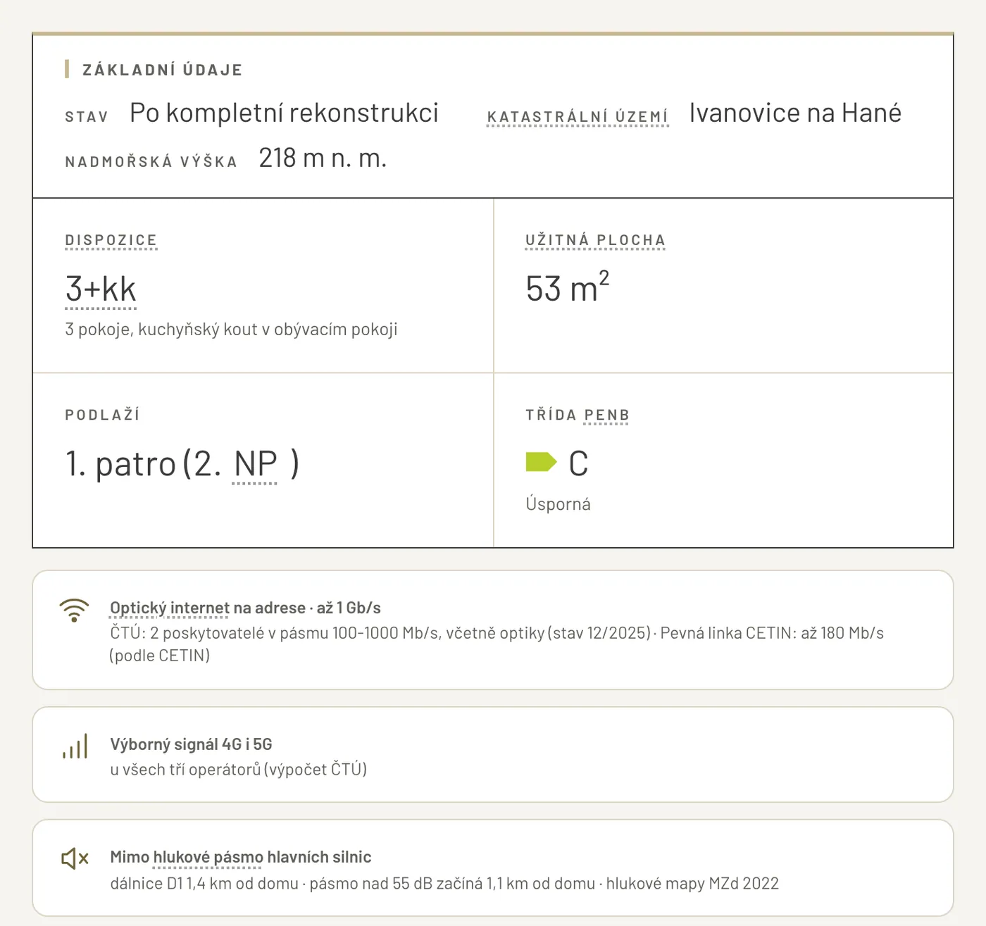
- Fixed connection at the address - type (fibre, xDSL, wireless) and top speed
- 4G and 5G coverage for all operators
- Noise in the area according to strategic noise maps
Sources: Czech Telecommunication Office - VPortal (fixed internet and signal coverage, with ČTÚ consent), Ministry of Health - strategic noise maps 2022
Who lives here
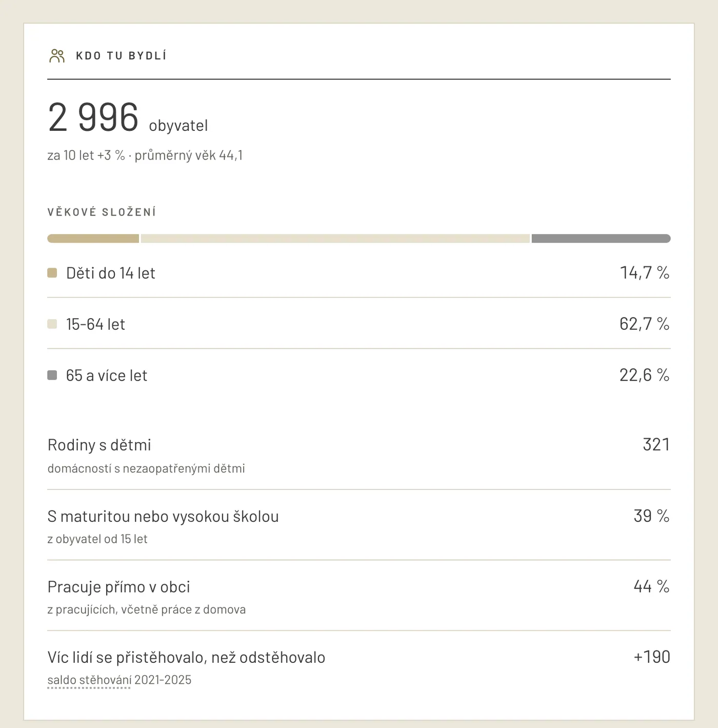
PremiumWhat the municipality is like - young, growing, family-friendly?
What it shows
- Population and its change over 10 years
- Age structure and average age
- Share of families with children and education
- Net migration - how many people moved in and out
Sources: Czech Statistical Office - municipal demographics and census results
Sun, shade and climate
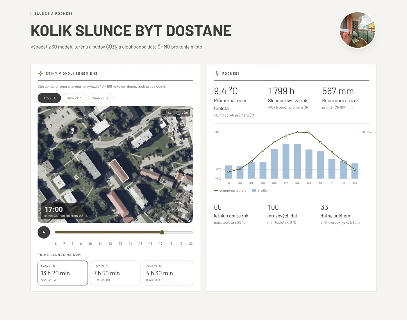
PremiumHow much sun the windows get and how shadows move around the area.
What it shows
- Hours of direct sun in the windows in summer, spring and winter - with shading by nearby buildings, trees and terrain
- Shadows of buildings and trees around the property hour by hour with a slider
- Temperatures, rainfall and sunny days per year from climate normals
Sources: ČÚZK - digital surface and terrain models (DMP 1G, DMP OK, DMR 5G), RÚIAN (building outline); CHMI - climate normals 1991-2020
How the area has changed
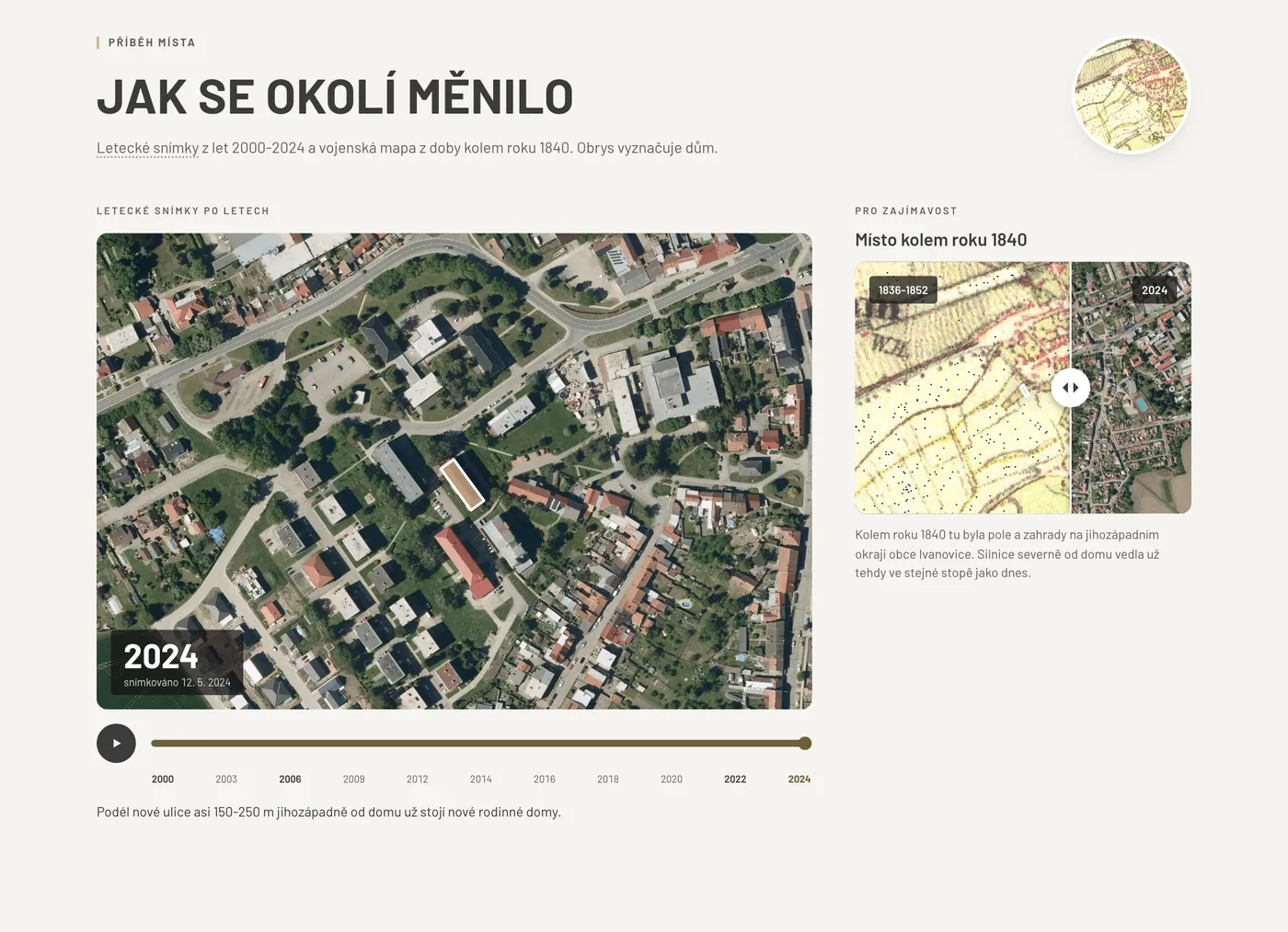
PremiumThe story of the place that buyers will not find elsewhere.
What it shows
- Aerial images of the area over the years with a slider
- Historical map from around 1840
- A short story of the place - what was here and how it grew
Sources: ČÚZK - archive and current orthophoto; CENIA - Second Military Survey
Plot, zoning and surroundings
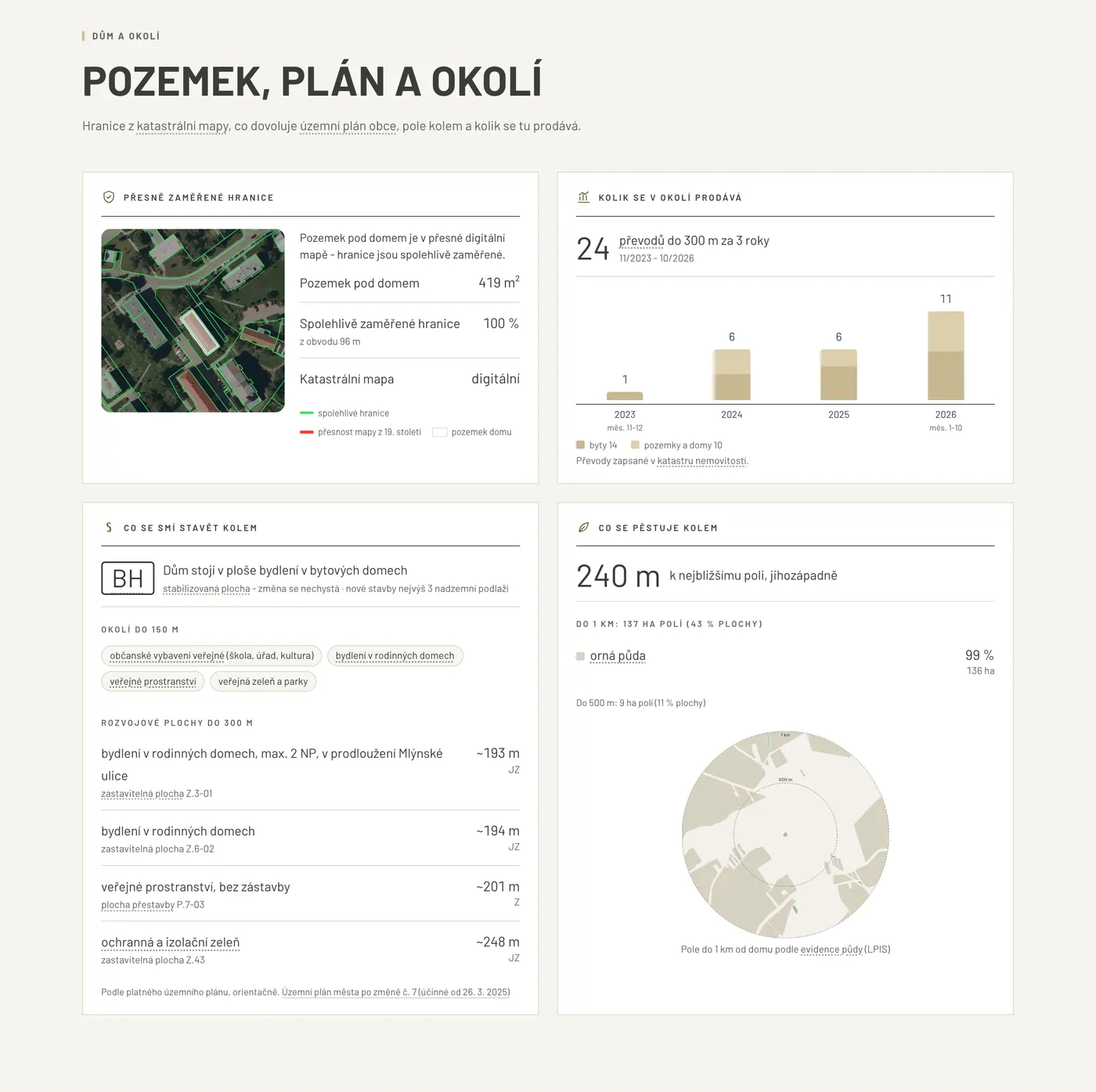
PremiumWhat may be built nearby, how precise the boundaries are and how much sells here.
What it shows
- Precisely surveyed plot boundaries according to the quality of the cadastral map
- What the zoning plan allows on the plot and next door - zones, height limits, development areas
- What is grown in the fields around
- How much sells nearby - number of transfers recorded in the land register, without prices or names
- For houses and plots, soil quality - BPEJ, protection class and official price
- A walk down the street in the Mapy.com panorama
Sources: ČÚZK (cadastral map, RÚIAN, BPEJ), municipal zoning plan, LPIS (Ministry of Agriculture), VÚMOP, Decree No. 441/2013 Coll., Mapy.com Panorama (link only)
Family and work
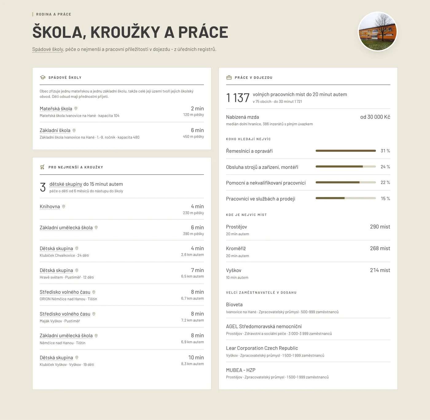
PremiumWhat families with children care about most.
What it shows
- Catchment primary school and nursery with walking time
- Children's groups, activities, art school and library
- Jobs within 20 and 30 minutes by car - vacancies, offered pay, sectors and large employers
Sources: Ministry of Education - school register, municipal ordinances on school districts, Ministry of Labour - children's groups and job vacancies, Czech Statistical Office - business register, National Library
Weekend outings
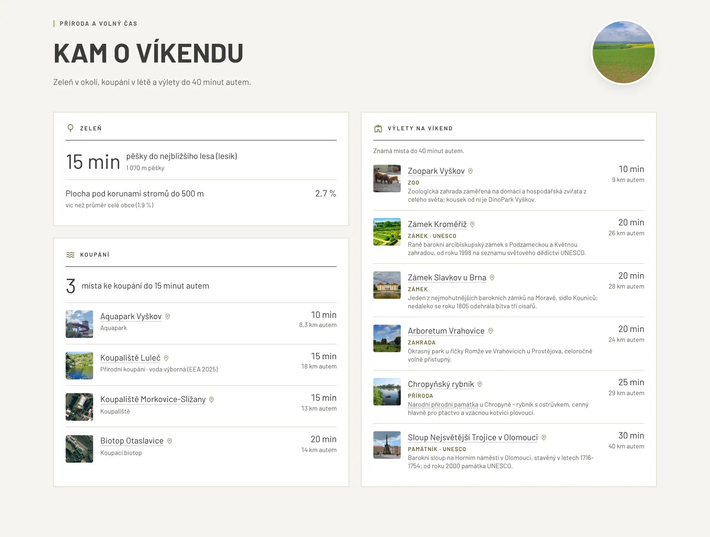
PremiumGreenery, water and trips within reach.
What it shows
- Parks, forests and the share of greenery nearby
- Swimming spots with water quality from the last season
- Trip ideas with driving time and a photo
Sources: Copernicus (tree cover), OpenStreetMap, Ministry of Health and EEA (bathing waters), Wikidata, Wikimedia Commons
Life in the town
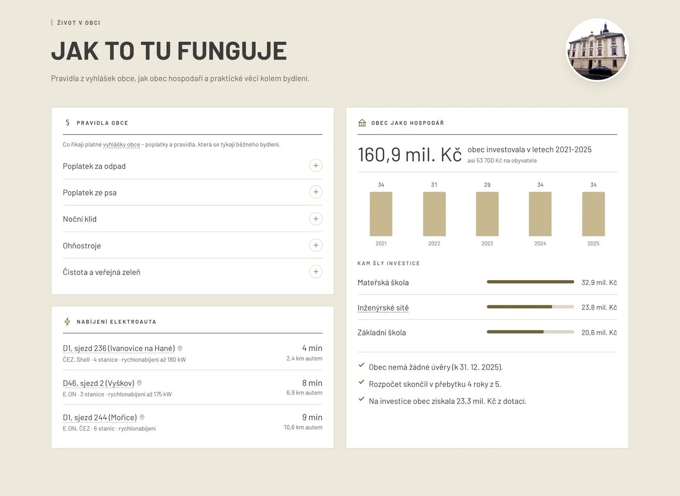
PremiumRules, fees and how the municipality manages its money.
What it shows
- What municipal ordinances say - waste and dog fees, night-time quiet and other rules
- The municipality's budget and investments over the last 5 years
- Charging stations for electric cars
- hermanice36.nmvt.cz/en/#site
Utilities and connections
PremiumWhat the property is connected to and which utilities are within reach - documented by the network operators.
What it shows
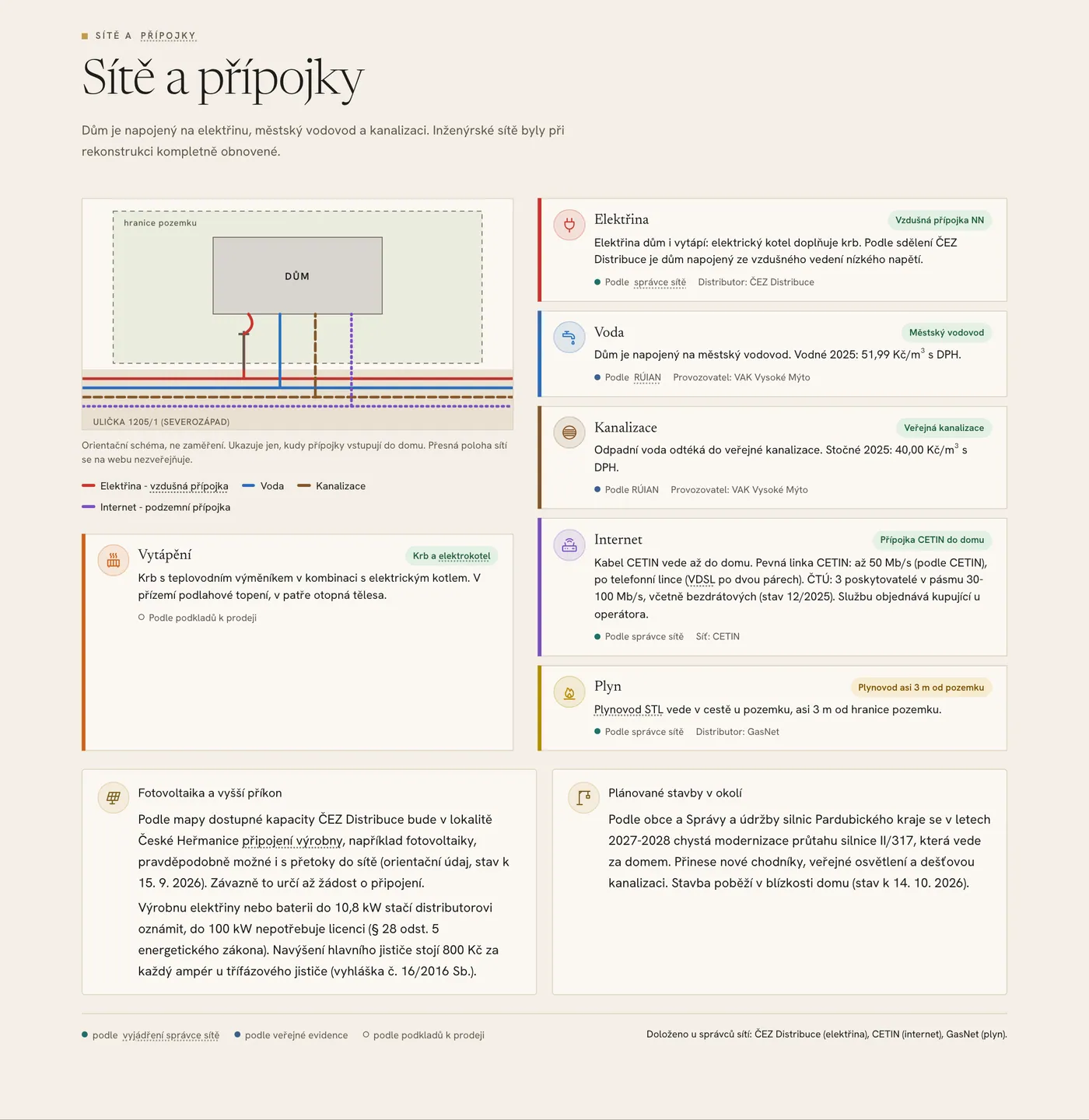
- Electricity, water, sewerage, gas, internet and heating on clear cards with an indicative connection diagram (a diagram, not a survey)
- We ask the network operators for a statement on the existence of networks ourselves - the card then carries the label “Per network operator”, for example for an overhead low-voltage connection. Otherwise the strongest other source, such as “Per RÚIAN” or “Per CTU”, and “Per sale documents” for details found only in the listing
- Water and sewerage per the operator including water and sewage charges, internet with the speed stated by the network operator and the number of providers at the address
- Solar panels and higher power - what the distributor's map shows for the area (with its date) and when a plant only needs to be notified
- Planned works nearby from the municipal notice board and website, such as new pavements or road repairs
Example from a pilot house in České Heřmanice: electricity “overhead LV connection” per ČEZ Distribuce, internet “CETIN line to the house” up to 50 Mbps per CETIN, and the modernisation of road II/317 through the village in 2027-2028 per the municipality. We never show utility routes or extracts from network operators' maps on the public website. Operator information is presented as they stated it and does not replace their statements for building work.
Sources: Agent's documents, network operators (statements on the existence of networks, internet availability, capacity map for power plants), water and sewerage operator, ČÚZK (RÚIAN), Energy Regulatory Office (distributor licences), ČTÚ (internet at the address), municipal notice board and website, Energy Act and connection decree
Premium
Location check for the agent
A password-protected page and PDF (Premium). The agent also finds what does not belong on the website - to know the risks before buyers do and to have answers ready.
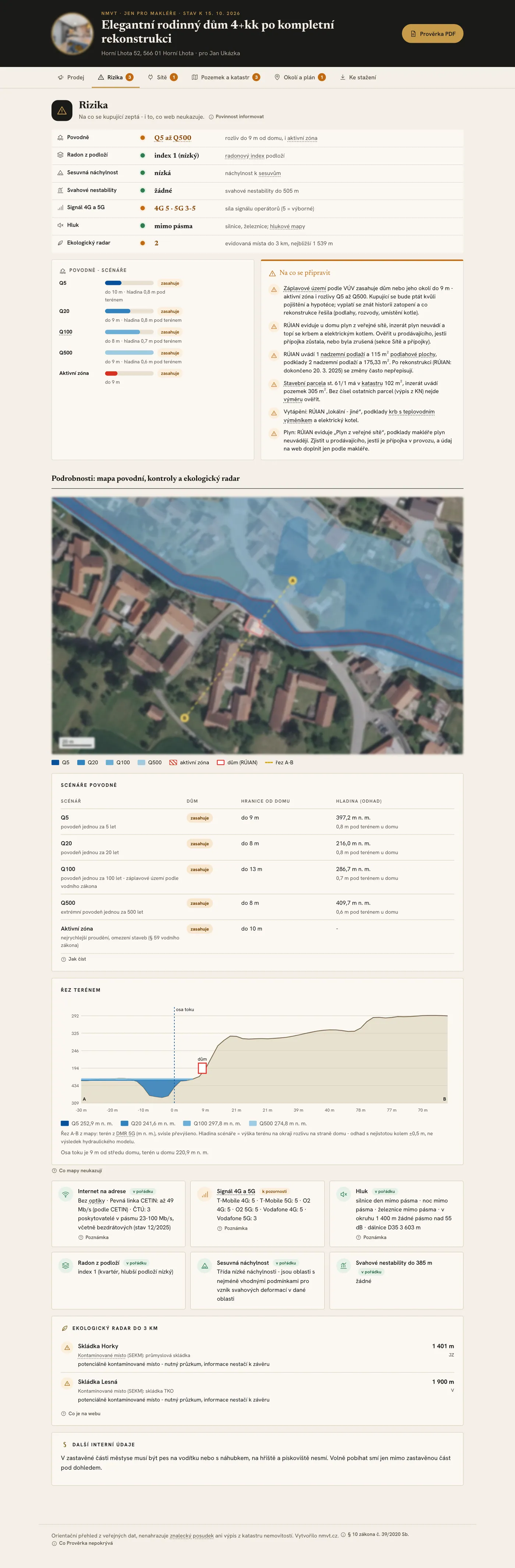
Summary and what to prepare for
Overview of all areas with a colour status, questions buyers are likely to ask and arguments for buyers.
Floods
Designated flood zones Q5 to Q500 and active zones compared with the building outline, a scenario map and a terrain profile.
Radon and landslides
Radon index of the subsoil, landslide susceptibility and the slope instability register.
Environmental radar
Contaminated sites, facilities from the pollution register, landfills, biogas plants, mining areas and undermined areas nearby.
The house in the land register
Parcels, land type and areas from the title deed compared with the land register and the listing.
Land register and surroundings
Owner type of neighbouring plots and the access road, easements, boundary accuracy, discrepancies, transfers and parcel changes nearby - without prices or names.
The whole zoning plan
Including unfavourable zones nearby, public benefit constructions and reserved areas.
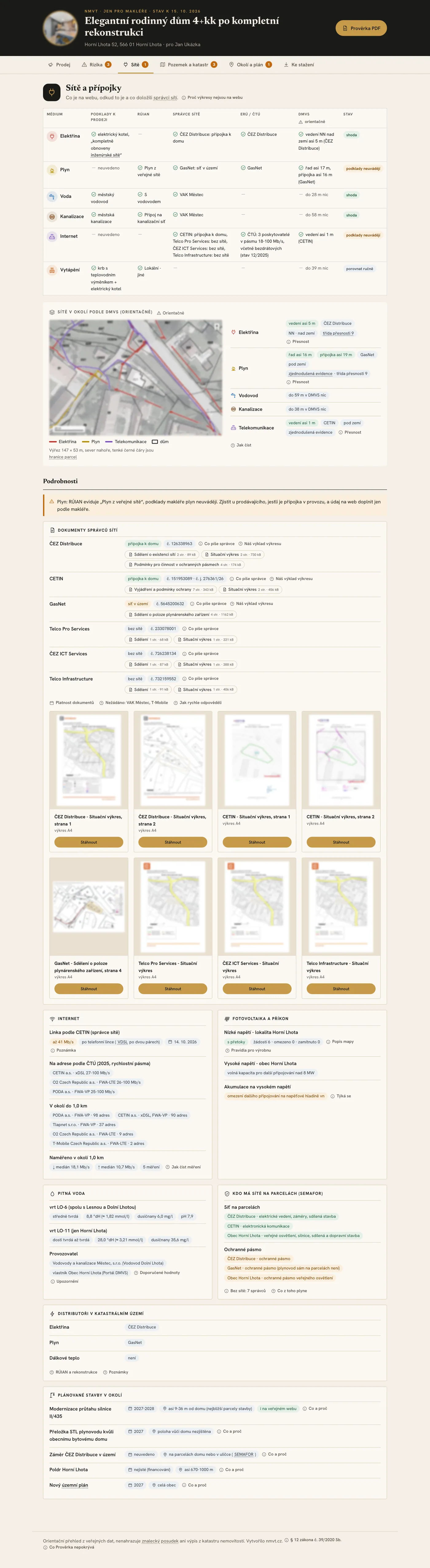
Utilities - operator documents and registers
Complete statements from network operators with drawings and validity, a timeline of the requests and a comparison of the agent's documents, registers and operators. Plus the operators in the area according to SEMAFOR, internet nearby with measured speeds and drinking water hardness from the operator.
Investment view for flats
Indicative rent from the rent price map and gross rental yield.
Links and the land registry office
Cadastre viewer, contact for the competent land registry office and the change alert service.
Where the data come from
Only publicly available sources of authorities, institutions and open data. On the website they are listed in the “Data sources” window in the footer, in the location check next to each area.
- ČÚZK
- land register, RÚIAN, orthophoto, elevation, BPEJ, DMVS portal
- Czech Statistical Office
- population, business register
- Czech Telecommunication Office
- internet at the address, signal coverage, NetTest measured speeds
- CHMI
- climate normals
- Ministries of Education and Labour
- schools, children's groups, job vacancies
- Ministry of Health
- noise maps, bathing waters
- VÚV TGM
- flood zones
- Czech Geological Survey
- radon, landslides, deposits
- Ministry of the Environment and CENIA
- contaminated sites, pollution register, historical maps
- Ministry of Agriculture and VÚMOP
- LPIS, BPEJ characteristics
- Municipalities
- zoning plans, municipal ordinances, planned works, water and sewage charges
- Ministry of Finance
- municipal budgets, rent price map
- ERO and Ministry of Industry
- energy distributors, charging stations
- Network operators and water companies
- statements on the existence of networks, internet availability, capacity maps for power plants, water hardness
- Timetables
- GTFS of integrated systems, CIS JŘ
- Open data
- OpenStreetMap, Copernicus, Wikidata, Wikimedia Commons
Rules we follow
- Only favourable and neutral information on the website. Risks and sensitive information are in the agent's location check.
- We never change or recalculate the agent's figures. Discrepancies with the registers are pointed out.
- We never show transfer prices or owners' names - only counts and owner type.
- Every figure has a source and the date it applies to. A block without reliable data is left out.
- The analysis is informative - it is not an expert valuation or legal advice. Official sources such as the title deed are binding.
Location analysis FAQ
How long does the location analysis take?
It is part of the property website. Premium with the full analysis and location check is delivered express within 48 hours of complete documents, Basic with amenities and driving times within 5 working days. Utilities depend on the network operators: their statements usually arrive within minutes or hours, but by law they have up to 30 days.
Does it work for a flat?
Yes. For flats the location check adds an investment view; soil quality is mainly for houses and plots.
How do you know what the house is connected to?
From the agent's documents, the RÚIAN address register and statements from the network operators that we request ourselves - the agent does not need to look anything up or fill in any forms. Each card says where the information comes from. Operator information does not replace their statements for building work.
Will buyers see the risks?
The website shows only favourable and neutral information. Risks such as flood zones or radon are in the agent's location check - the agent can work with them and tell buyers in line with their duty to disclose.
Why is a block missing on the website?
If there are no reliable data for the address, or the information is unfavourable, the block does not go on the website. Unfavourable information is in the location check.
Is it an expert valuation?
No. The location analysis clearly presents publicly available data about the place. It does not set the property price and does not replace the title deed or other official documents.
Want a location analysis for your property?
Send us the documents and get a property website with a location analysis - and with Premium also the location check for the agent.